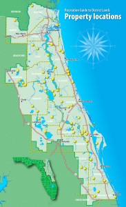
St. John’s River Water Management Districts Recreational Lands

Those individuals seeking recreational opportunities near the central eastern geographic area of Florida will find a very valuable resource available through the St. John’s River website. This water management district manages a large area of public land in protection of the St. John’s River watershed and has a great deal of helpful information available on their website.
Within the associated pages and links, you will be able to locate a wealth of maps and information related to the activities offered to those seeking to experience the lands managed by this department.
Click on the graphic to follow to the recreational section of the SJR WMD website interactive map where you can select available properties of interest. ►
Maps to the properties can be obtained from the links available on the St John’s Water Management District website or can be easily selected directly from the list below. The links we have provided are the most recent from the SJRWMD website.
SJRWMD Trail guide maps
Trail guide maps for recreational properties of the St John’s WMD
- Bayard Conservation Area
- Black Creek Ravines Conservation Area
- Buck Lake Conservation Area
- Caravelle Ranch Wildlife Management Area
- Clark Bay Conservation Area
- Crescent Lake Conservation Area
- Deep Creek North Conservation Area
- Dunns Creek Conservation Area
- Econlockhatchee Sandhills Conservation Area
- Fort Drum Marsh Conservation Area
- Gemini Springs Addition
- Hal Scott Regional Preserve and Park
- Heart Island Conservation Area
- Julington-Durbin Preserve
- Lake Apopka Restoration Area
- Lake George Conservation Area
- Lake Jesup Conservation Area
- Lake Monroe Conservation Area
- Lake Norris Conservation Area
- Longleaf Flatwoods Reserve
- Moccasin Island (River Lakes Conservation Area)
- Moses Creek Conservation Area
- Murphy Creek Conservation Area
- Murphy Island at Murphy Creek Conservation Area
- Newnans Lake Conservation Area — Hatchett Creek Tract
- Newnans Lake Conservation Area — North Tract
- Newnans Lake Conservation Area — South Tract
- Ocklawaha Prairie Restoration Area
- Orange Creek Restoration Area — South Tract
- Orange Creek Restoration Area — North Tract
- Palm Bluff Conservation Area
- Pellicer Creek Conservation Area
- Ralph E. Simmons Memorial State Forest
- Rice Creek Conservation Area
- Stokes Landing Conservation Area
- Sunnyhill Restoration Area
- Thomas Creek Conservation Area
- Three Forks Conservation Area
Special guides for recreation land
Blue Cypress Conservation Area Paddling Guide
- Interpretive information
- Map
Emeralda Marsh Conservation Area Interpretive Drive
- Interpretive information
- Map
Lake George Conservation Area Self-Guided Auto Drive
- Interpretive information
- Map
Lochloosa Wildlife Conservation Area Self-Guided Auto Drive
- Interpretive information
- Map
Twelve Mile Swamp Conservation Area Interpretive Trail
- Interpretive information
- Map
